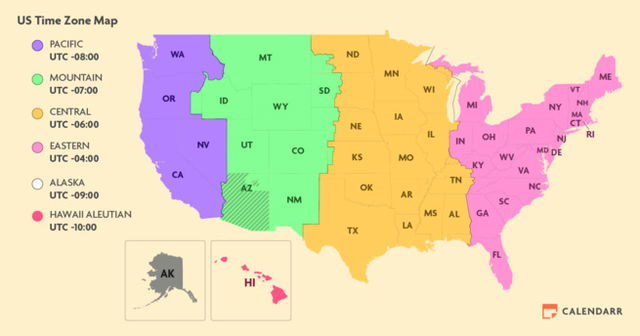
The United States is divided into nine standard time zones. These are spread across the country's fifty states and include overseas territories. These time zones are defined by the Coordinated Universal Time (UTC), a global time standard used for international communication, aviation, and many other purposes.
Most Americans live in one of the six time zones that cover the fifty states, these time zones are:
- Eastern Time Zone (ET)
- Central Time Zone (CT)
- Mountain Time Zone (MT)
- Pacific Time Zone (PT)
- Alaska Time Zone (AKT)
- Hawaii-Aleutian Time Zone (HAT)
Where we Live
The United States is home to over 340 million Americans. They live in either the contiguous United States, the states of Alaska or Hawaii, or one of America's overseas territories. Each has its own time zone:
The Big Four
The vast majority of the population of America lives somewhere in the contiguous United States, where we have four time zones. Many of the states are not completely within a single timezone, but rather, due to their size, are divided between two different time zones:
Eastern Time Zone (ET)
The Eastern Time Zone covers the easternmost parts of the contiguous United States. It covers the most states of all the time zones, consisting of twenty-two complete states from the Atlantic coast to the eastern border of the Central Time Zone:
| Maine | Maryland | Massachusetts | New York |
| New Jersey | Connecticut | Delaware | Georgia |
| New Hampshire | North Carolina | Vermont | Virginia |
| West Virginia | Ohio | Pennsylvania | Rhode Island |
| South Carolina | Michigan | Tennessee | Florida |
| Indiana | Kentucky | part of Michigan | part of Tennessee |
| part of Florida | part of Indiana | part of Kentucky |
Central Time Zone (CT)
To the west of the Eastern Time Zone, the next time zone is the Central Time Zone (CT). It covers a vast area, including nine states in their entirety, stretching from the Mississippi River to the eastern edge of the Mountain Time Zone:
| Alabama | Arkansas | Illinois | Iowa |
| Louisiana | Minnesota | Mississippi | Missouri |
| Wisconsin | part of Florida | part of Indiana | part of Kentucky |
| part of Michigan | part of Tennessee | part of Kansas | part of Nebraska |
| part of North Dakota |
Mountain Time Zone (MT)
The Mountain Time Zone (MT) covers the Rocky Mountains and stretches from the western border of the Central Time Zone to the eastern boundary of the Pacific Time Zone.
| Arizona | Colorado | part of Idaho | part of Kansas |
| Montana | part of Nebraska | New Mexico | part of North Dakota |
| part of Oregon | part of South Dakota | part of Texas | Utah |
| Wyoming | part of Nevada | part of South Dakota | part of Texas |
Pacific Time Zone (PT)
Located on the westernmost edge of the United States, the Pacific Time Zone (PT) covers the fewest states in the contiguous United States:
| California | Washington | part of Alaska | part of Idaho |
| part of Nevada | part of Oregon |
The Smaller Two
Alaska Time Zone (AKT)
The Alaska Time Zone (AKT) is followed in Alaska, a state separated from the continental United States by Canada. Alaska observes a unique time zone due to its significant distance from the rest of the country.
Hawaii-Aleutian Time Zone (HAT)
The Hawaii-Aleutian Time Zone (HAT) is observed in Hawaii and the westernmost part of the Aleutian Islands in Alaska. It is the last time zone in the United States and is four hours behind Eastern Time.
The Oversea Territory
Apart from the six primary time zones, the United States has three additional time zones for specific territories. These include:
Atlantic Time Zone (AT): The Atlantic Time Zone is followed in Puerto Rico and the U.S. Virgin Islands, located in the Caribbean. It is one hour ahead of Eastern Time.
Samoa Time Zone (SST): The Samoa Time Zone is observed in American Samoa, a group of islands in the South Pacific. It is three hours behind Pacific Time.
Chamorro Standard Time Zone (ChST): This time zone is followed in Guam and the Northern Mariana Islands, both located in the western Pacific Ocean. It is fifteen hours ahead of Eastern Time.
Why We Have Timezones
Time zones are geographical regions that share the same standard time. The primary purpose of dividing the world into time zones is to ensure that time remains relatively consistent within a given area. Each time zone represents a 15-degree segment of longitude, roughly corresponding to the Earth's rotation every hour. As one moves from west to east, time advances by an hour with each time zone crossed.
Discovering More
The United States' time zones have not always been as we know them now. They have changed over the years, reflecting the diversity of our nation, and they experience discrepancies, quirks, and challenges:
-
Daylight Saving Time (DST) can sometimes lead to confusion. Not all US states observe DST, meaning certain regions may remain on standard time throughout the year. Arizona, with the exception of the Navajo Nation, does not participate in DST. Additionally, Hawaii, Guam, Puerto Rico, and the U.S. Virgin Islands also do not observe DST. This can cause confusion when scheduling or communicating across state lines.
-
Until 2006, the state of Indiana had an unusual time zone situation. Most of the state followed Eastern Time, while a few counties in the northwest followed Central Time. However, in an effort to streamline timekeeping, Indiana adopted Daylight Saving Time statewide in 2006. This change caused some confusion initially, but it ultimately led to greater consistency within the state.
-
Navajo Nation and the Daylight Saving Time Exemption: The Navajo Nation, located in parts of Arizona, New Mexico, and Utah, follows Mountain Time for most of the year. However, it does not observe Daylight Saving Time. Instead, it remains on standard time throughout the year. This exemption does maintain consistency and also better aligns with traditional cultural practices.
To learn more about Daylight Saving and how its practice has changed over the years: Daylight Saving


